

There was a time Columbus dared to dream a little bigger.
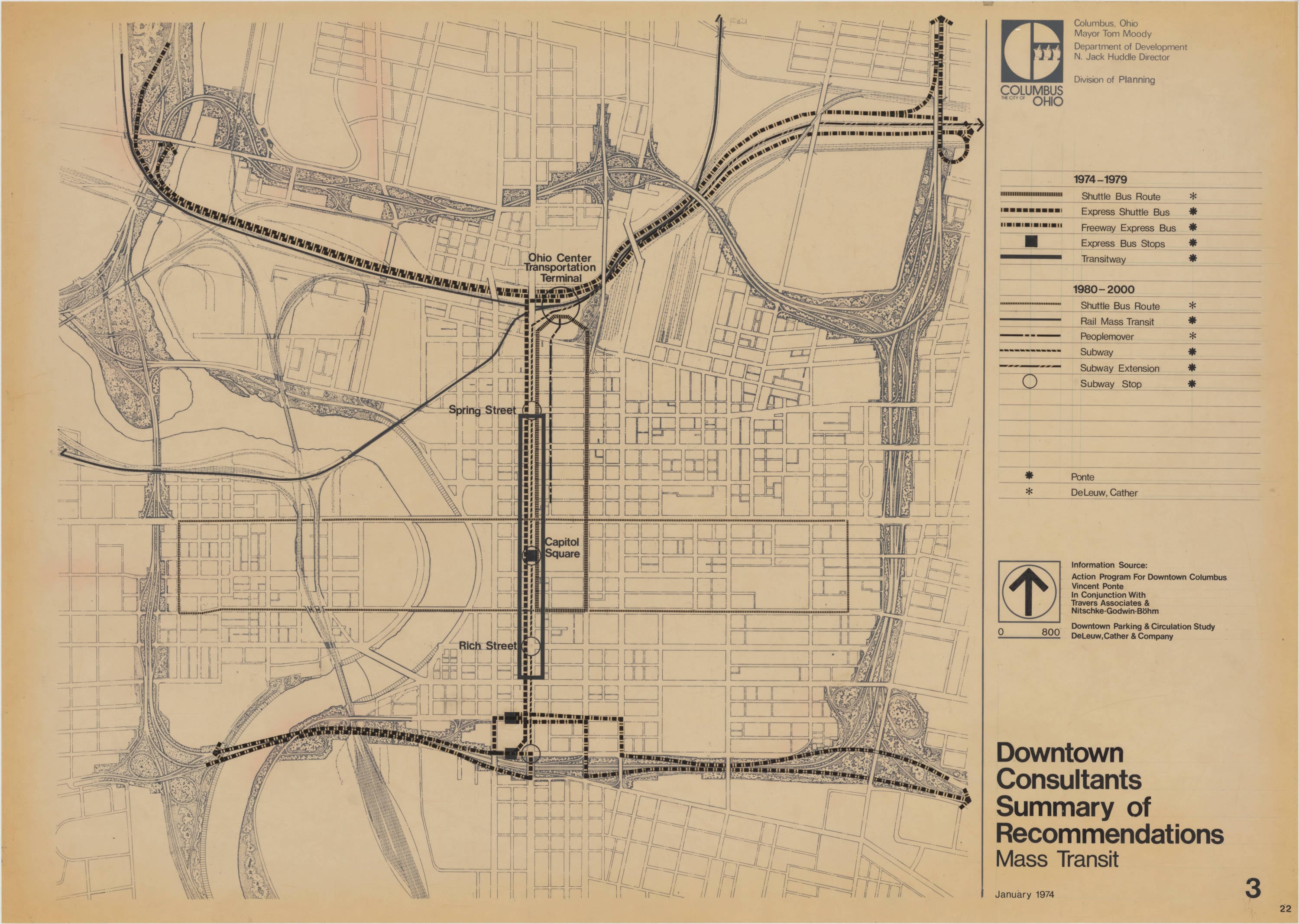
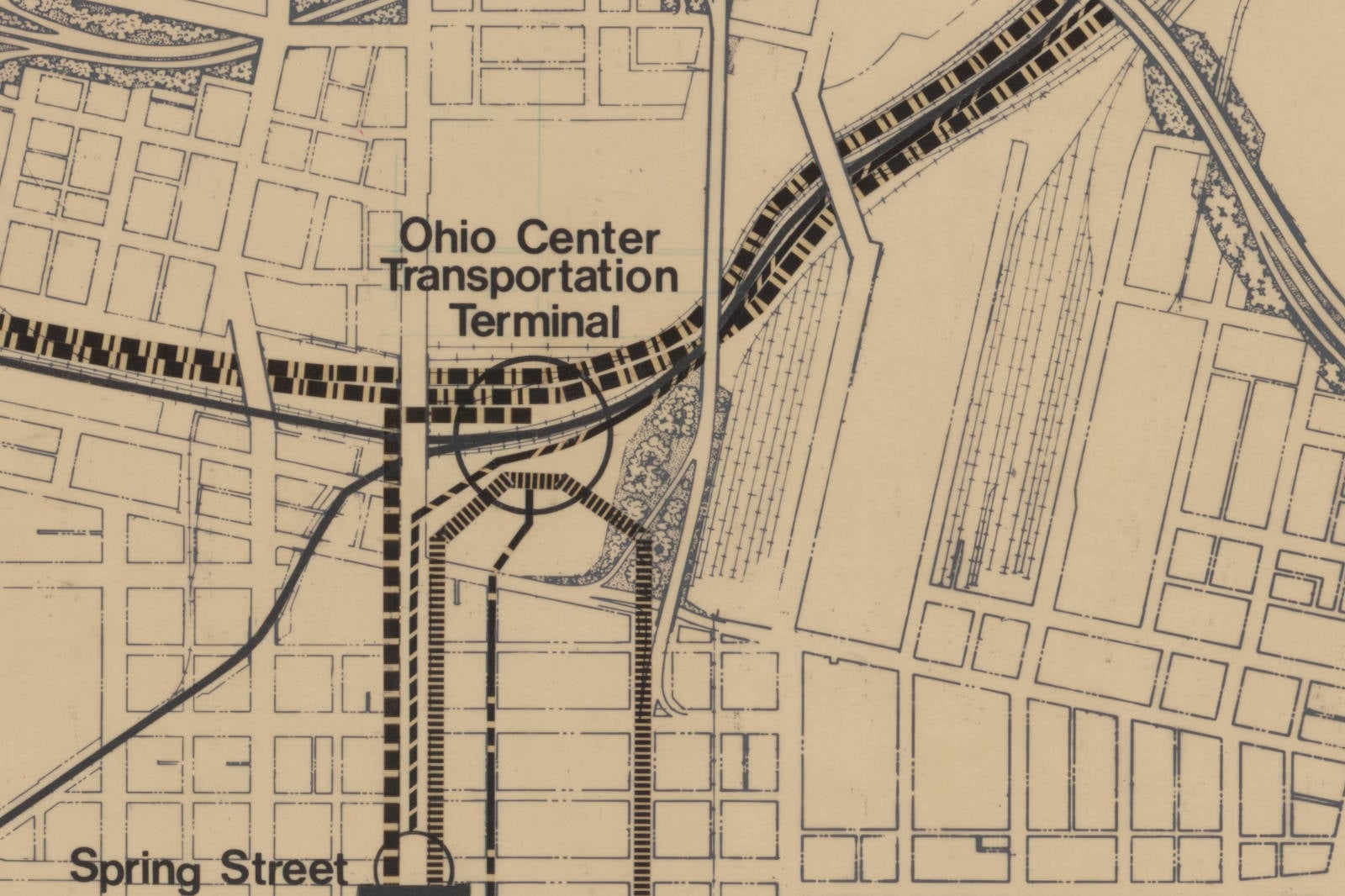
Page 22 of a 1974 city planning volume shows a subway running under High Street. Five open circles mark stops along it. Four carry names: Rich Street, Capitol Square, Spring Street, and, at the north end in the rail corridor just east of High where Union Station still stood, a station called the Ohio Center Transportation Terminal.
The Columbus Metropolitan Library has digitized exactly one page out of that volume. It’s titled “Downtown Consultants Summary of Recommendations: Mass Transit,” it’s dated January 1974, and Mayor Tom Moody’s name sits in the corner above the Division of Planning credit.
Most of what’s drawn on it came from Vincent Ponte, the planner who first envisioned Montreal’s underground city.
What The Sheet Actually Is
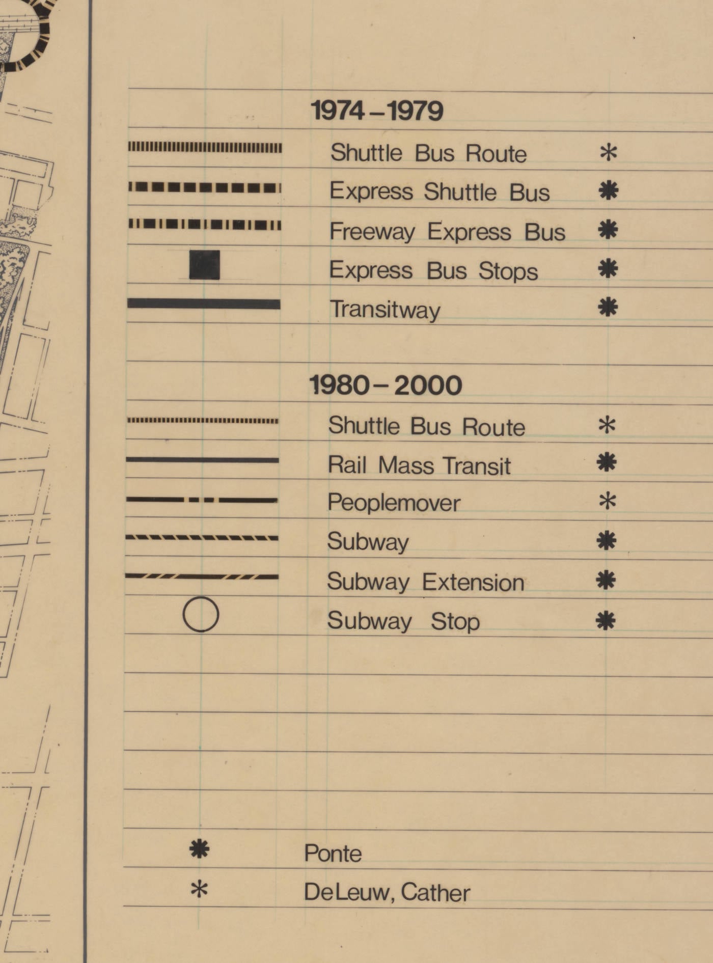
The map isn’t a concrete plan. It’s the city’s summary of two outside consultant reports, redrawn so the Division of Planning could see both sets of recommendations on one page. A small key in the legend marks each line with the name of whoever proposed it.
One source was the “Action Program For Downtown Columbus,” credited on the sheet to Vincent Ponte working with Travers Associates and the Columbus firm Nitschke-Godwin-Böhm. The other was the “Downtown Parking & Circulation Study” by DeLeuw, Cather & Company of Chicago.
Split by phase, the recommendations looked like this.
1974 to 1979: a shuttle bus route (DeLeuw Cather), an express shuttle bus, freeway express buses, express bus stops, and a transitway (the last four all Ponte).
1980 to 2000: another shuttle bus route and a peoplemover (DeLeuw Cather), plus rail mass transit, a subway, a subway extension, and subway stops (all Ponte).
So the buses came first and the rail came second, with the whole program finished by the year 2000. The subway, the rail line, the transitway, and the freeway express buses are all Ponte’s. The peoplemover and the local shuttle loops belong to DeLeuw, Cather.
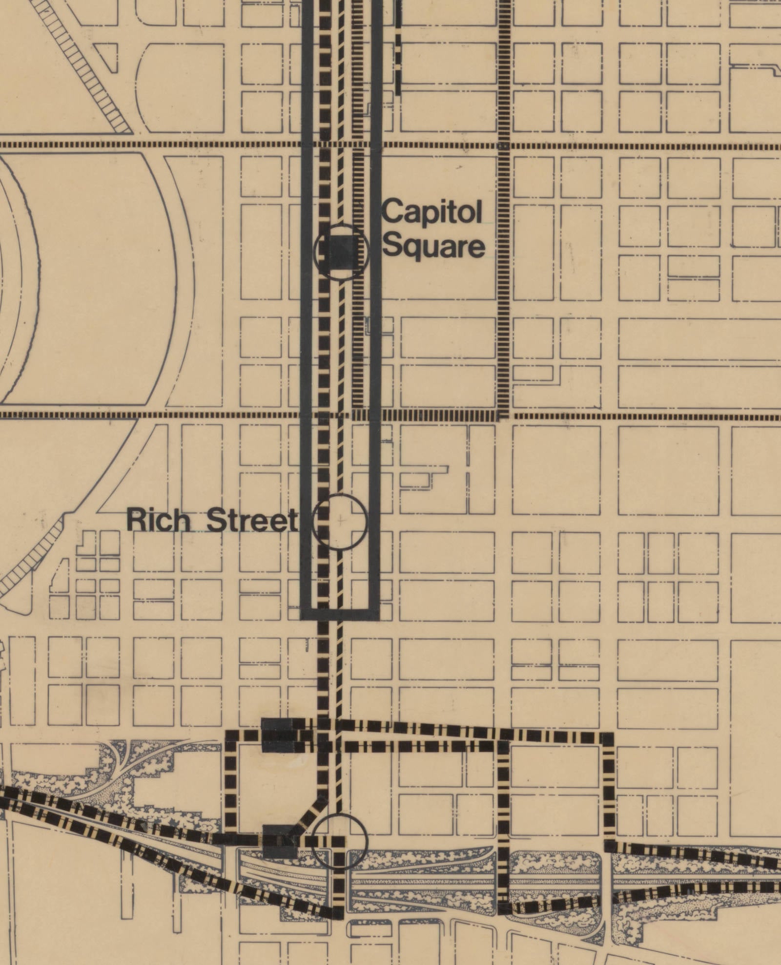
The subway itself runs the length of High Street. The subway extension breaks away at the terminal and runs east along the railroad corridor, off the edge of the sheet.
Who Vincent Ponte Was
Vincent Pasciuto Ponte was born in Boston in 1919 and took a fine arts degree from Harvard in 1949. He worked for I.M. Pei’s firm in New York before moving to Montreal in 1964. He drafted the master plans for Place Ville Marie and Place Bonaventure, and the climate-controlled pedestrian network running under downtown Montreal started as his idea. He did a version of the same thing for downtown Dallas. He died in 2006.
By the early 1970s the city’s own reports were listing his prior work in Paris, Brazil, Atlanta and Montreal, and Columbus hired him.
How Columbus Got Him
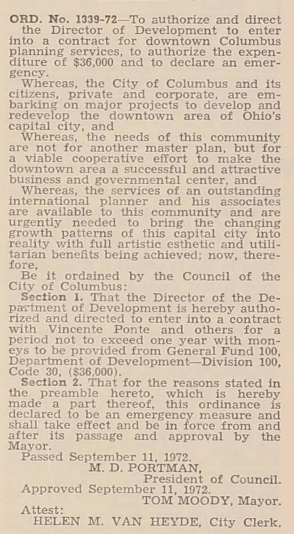
On September 11, 1972 Columbus City Council passed Ordinance 1339-72, which authorized the Director of Development to sign a downtown planning contract and spend $36,000 on it. The ordinance doesn’t name a firm in its title, but the text is unusually candid about what the city was buying.
“The needs of this community are not for another master plan, but for a viable cooperative effort to make the downtown area a successful and attractive business and governmental center,” it reads, and the next clause explains that “the services of an outstanding international planner and his associates are available to this community and are urgently needed.” Section 1 names him: a contract with “Vincente Ponte and others,” misspelled, for a period not to exceed one year.
Four and a half months later the city went back for more. Ordinance 174-73, passed January 29, 1973, increased Ponte’s Contract 303550 by another $58,800, declaring an emergency because letting the work lapse would curtail “a vital service to the City of Columbus.” That’s $94,800 of general fund money on a planner, in 1972-73 dollars.
Moody was proud of it. His own section of the city’s 1972 annual report lists downtown development as “probably the most visible area of achievement in 1972,” and credits “the hiring of internationally famous Vincent Ponte and his planning team.”
What Ponte Actually Recommended
Ponte “was hired in 1972 as a consultant to assist in the initiation of development coordination activities in the downtown core,” working for the Department of Development’s Division of Planning alongside Travers and Associates, “who specialize in traffic and transportation engineering,” and Nitschke-Godwin-Böhm, “a Columbus planning and urban design firm.”
Nitschke-Godwin-Böhm later merged into NBBJ, which still runs a Columbus office today.
By 1973 the annual report was calling them the “Ponte-Travers-Nitschke consultant team” and listing what they’d released under the Action Program for Downtown Columbus. The finished work ran to four volumes covering access and circulation, Broad Street, High Street, and pedestrians and parking.
A 1988 task force report to Downtown Columbus Inc. summarizes what was in them. It was produced with the city’s Planning Division and with Bohm-NBBJ, by then the successor to the same Columbus firm that had helped draw the plan. The plan was known simply as the Ponte Plan. It recommended new riverfront parks, later built as Bicentennial and Battelle. It proposed portal parks at the major entrances to downtown, the restoration of Broad Street as a landscaped boulevard, “the conversion of High Street to a public transitway,” and “a proposal for a subway running below High Street.”
Then there’s the part that sounds most like Montreal. A July 1974 Downtown Redevelopment Memo calls him “Vincent Ponte, Planning Consultant to the City,” and lists his capital improvement proposals for the blocks south of the Statehouse. Among them are second-level walkways and a below-grade walkway running from the Statehouse garage to a new plaza, alongside the High Street transitway. The memo’s own recommendation is blunt: “Mr. Ponte’s proposal for an underground connection to the State House should be carried out.”
He was hired to fix downtown Columbus, and he reached for the same tools he’d used on Montreal.
The Timing Was Brutal
January 1974 was difficult timing.
COTA had been operating for less than a month. The authority began service on January 1, 1974, after buying the privately owned Columbus Transit Company for $4.8 million. The program drawn on the sheet ran to the year 2000, and the agency that would have to run most of it was a new government agency that had just absorbed a failing bus company.
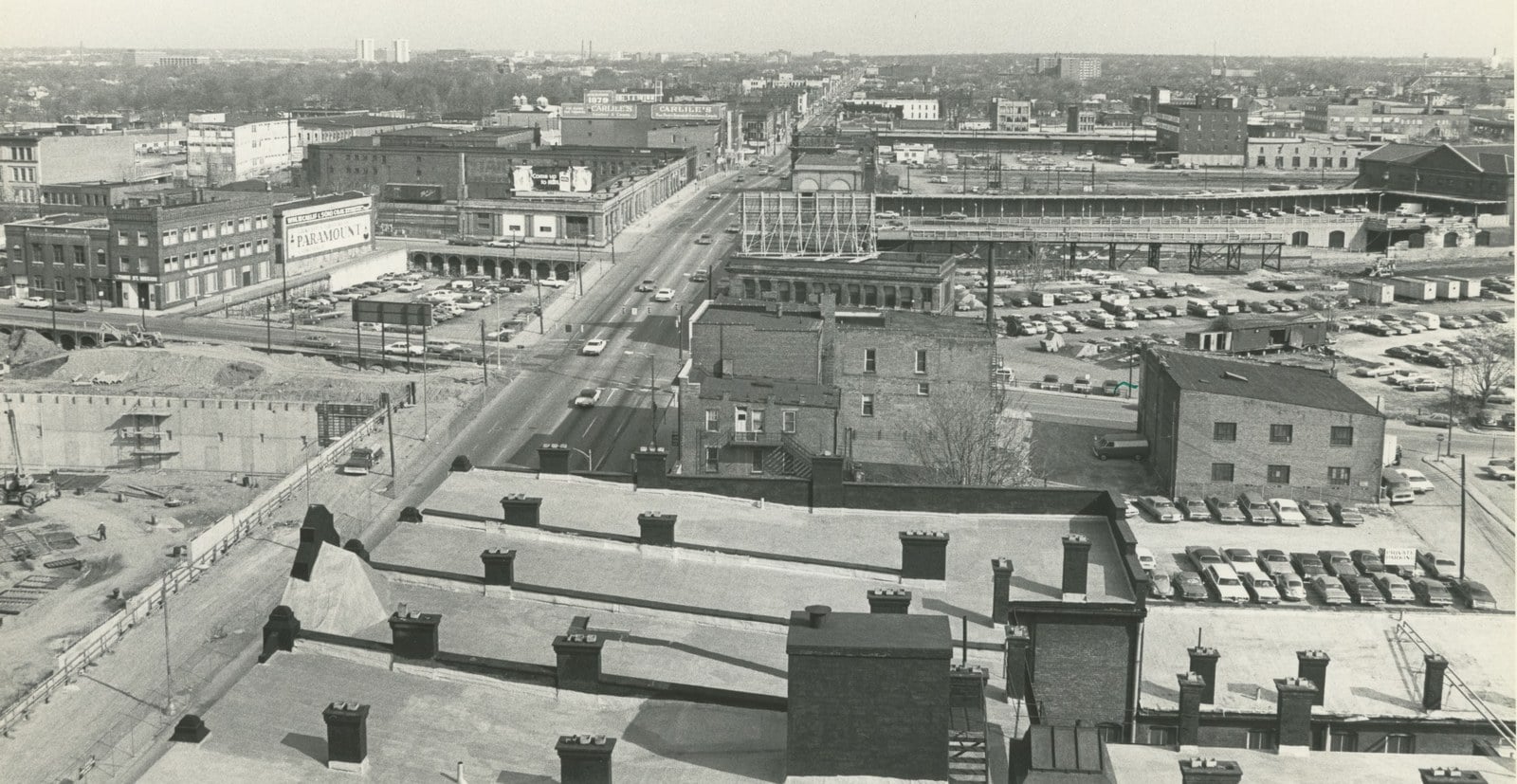
The north anchor was in trouble too. Union Station saw its arcade added to the National Register of Historic Places on January 17, 1974, the same month as the map, and it was knocked down in October 1976 to clear the site for a convention center. One of the arcade’s arches survived and now stands in McFerson Commons in the Arena District.
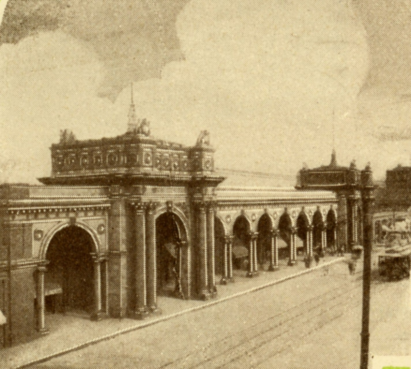
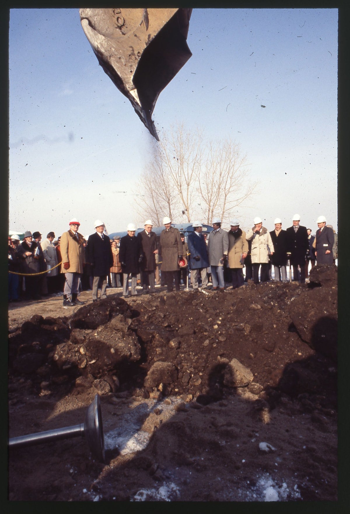
A transit hub was supposed to go there. Battelle Commons, backed by COTA, sought federal money for a terminal called TransCenter inside the restored arcade, with ticket offices and entranceways to transit below street level. The arcade came down first. The convention hall that replaced it, the Ohio Center, opened in September 1980 with no transportation terminal attached.
What Survived And What Didn’t
Plenty of the Ponte Plan became reality. Bicentennial and Battelle parks were built. Broad Street got landscaping. The city stood up an in-house urban design group to help implement the consultants’ recommendations, and it kept exploring Ponte’s ideas well after his contract ran out. In July 1975, council put a further $35,000 toward engineering studies of two freeway connectors “proposed in the Ponte ‘Progress Report 1, Access and Circulation.'”
The rail half, of course, never happened. No subway referendum or construction appropriation turns up in the city’s bulletins from those years. The terminal came closer. In June 1974, five months after this sheet was drawn, council rushed through Resolution 175X-74 backing a federal submission to the U.S. Department of Transportation, one that took in the “Ohio Center intermodal” terminal and space “for rapid transit in the freeway design” along I-670. The deadline was four days out and the money would have been 90 percent federal. The terminal was never built.
Fifteen years later, a second 1988 task force report, this one on transportation, buried the subway in a single clause. It noted that the 1973 Ponte plan had called for one beneath High Street “as a long-range proposal, an idea which is now generally regarded as very costly.” The same page recommended an elevated people mover instead.
Columbus, in 2026, still has no rail transit. A 1984 plan revived the transit mall idea for High Street, between Main and Long, without the rail underneath. Three years after that came a proposal for a downtown monorail, but Columbus remains a car-centric city.
Fifty-Two Years Later
Columbus is finally designing dedicated transit lanes. LinkUS, the regional transit plan run jointly by COTA, the city, Franklin County and the Mid-Ohio Regional Planning Commission, has three bus rapid transit corridors in its first phase. Those are West Broad Street and East Main Street, plus a Northwest route from downtown past Ohio State up to COTA’s Bethel Road park and ride. West Broad sits at 90 percent design and waits on a federal funding decision. No dedicated bus lane is in the ground yet.
Notice which street isn’t on that list. High Street, the spine Ponte wanted turned over to transit in his very first phase, is not one of the three. COTA has looked at it since. A 2017 study sorted the region’s corridors by feasibility and found only one that could carry rail: High Street, from downtown to the far North Side. A downtown-to-Worthington line sits on the agency’s list of routes for future study.
The 1974 sheet put that transitway in the first phase, 1974 to 1979.
