I hope you all have your bread, milk, and eggs ready. It’s winter weather time.
If you’ve looked at the forecast even once this week, you already know central Ohio (along with a large portion of the U.S.) is staring down a wintry weekend. Several local stations are tracking the same storm system, but with slightly different details on timing, totals, and what could make things tricky.
Here’s a rundown of what Columbus-area meteorologists are saying right now, and what that means if you’re trying to plan your weekend.
A winter storm watch is already in place
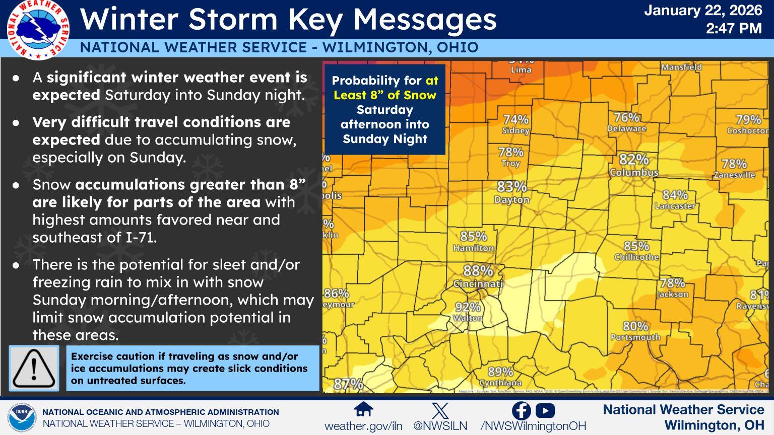
The National Weather Service has issued a Winter Storm Watch for many Ohio counties, starting Saturday morning. The storm is expected to impact a large swath of the country, but forecasters agree that Ohio sits right in a zone where snow totals could add up quickly.
The broad consensus is this. Snow arrives sometime Saturday afternoon or evening and sticks around through Sunday night.

How much snow could Columbus see?
This is where things start to vary slightly, though the overall message is consistent.
According to 10TV’s Weather Impact Team, much of the Columbus metro could see between 8 and 12 inches of snow by the time the storm winds down early Monday. Their latest forecast pushes heavier snow a bit farther north, with some of the highest totals expected south of I-70.
NBC4 is calling for a similar setup, though their forecast range is a bit wider depending on location. They currently have:
- • Northern parts of the viewing area: 4 to 8 inches
- • Columbus and much of central Ohio: 6 to 10 inches
- • Southern counties: 6 to 12 inches, with more uncertainty due to a possible mix
ABC6 is also forecasting 6 to 10 inches for Columbus, with higher totals south of the city. They note that locally higher amounts are still possible as the storm track becomes clearer.
Timing and travel impacts
Local meteorologists agree that Friday will likely stay dry but cold. Snow chances increase late Saturday, with the heaviest snowfall likely Saturday night into Sunday.
With the bulk of the snow arriving Sunday, heavy snow will rapidly worsen travel conditions. Officials are encouraging people to avoid traveling on Sunday if possible, citing fast accumulation and low visibility.
Bitter cold adds another layer
Unfortunately, it’s not just about snow totals. Cold is a major part of this forecast.
Temperatures are expected remain below freezing through the weekend and possibly through the rest of January. With wind chills dropping below zero late Friday into early Saturday, this storm is potentially shaping up as the coldest of the season so far.
Could there be a wintry mix?
One wildcard to watch is the potential for warmer air above the surface on Sunday.
According to NBC4, if that warmer layer pushes far enough north, parts of southern Ohio could see a mix of snow, sleet, or freezing rain. That would lower snow totals in those areas but could introduce slick conditions. For now, most forecasters expect snow to dominate, especially at the start of the storm.
What should you do now?
It’s time for preparation over panic.
That means keeping an eye on forecast updates, planning ahead if you need to travel, and making sure you’re ready for cold temperatures that could linger well into next week. With fresh snowpack on the ground, several meteorologists are warning that below-zero mornings may be possible after the storm moves out.
Bottom line. This is shaping up to be the most impactful winter weather we’ve seen so far this season, but there’s still room for changes. If you’re making weekend plans, flexibility is your friend.
So, Columbus, here’s our suggested game plan.
Stock up on groceries, locate all your coziest sweaters, and keep an eye on your neighbors, especially anyone who might need a little extra help staying warm and shoveling snow. Winter is coming in fast, and it’s not playing around. Stay safe and stay warm!
MORE LIKE THIS:
Where to Find Warming Shelters in Columbus This Winter
Featured image via Zach Vessels on Unsplash


